

What is Satellite Navigation?
- A satellite navigation system, sometimes known as a satnav, employs satellites to provide geospatial positioning on its own. Using time signals delivered along a line of sight by radio from satellites, satellite navigation equipment may pinpoint their location (longitude, latitude, and altitude/elevation) with great precision (within a few centimeters to meters).
- The system can be used to track the location of something equipped with a receiver, provide position information, or facilitate navigation (satellite tracking). The signals also enable the electronic receiver to precisely determine the current local time, enabling time synchronization.
- Positioning, navigation, and timing are the three terms used to refer to these applications (PNT). Although these technologies can improve the value of the positioning information produced, satnav systems work independently of any telephone or internet reception.
- A global navigation satellite system is a satellite navigation system that covers the entire world and also can be termed a Global Navigation Satellite System(GNSS). A satellite constellation consisting of 18–30 medium Earth orbit (MEO) satellites distributed across numerous orbital planes typically provides each system with global coverage. Although the actual systems differ, they all use orbits with inclinations greater than 50 degrees and periods close to twelve hours (at an altitude of about 20,000 kilometers or 12,000 miles).
How Does a Global Navigation Satellite System?
- GNSS satellites come in a variety of ages and designs, but their basic function is the same. The L1 and L2 carrier waves that the satellites use to transmit data are part of the L-Band. Information is sent from the satellite to the earth via carrier waves.
- Antenna and processing unit are the two main components of most GNSS receivers. The processing unit decodes the satellite signals as the antenna receives them. It must gather data from a minimum of three satellites to establish the location of the receiver.
- A medium-orbit GNSS satellite travels around the planet every 11 hours, 58 minutes, and 2 seconds. Each satellite sends out coded signals that are time-stamped with an atomic clock and contain information specific to that satellite’s orbit.
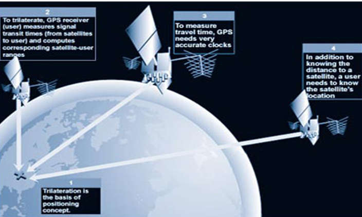
- The receiver can continuously determine the time the signal was broadcast by receiving the time information sent by satellite as codes. The signal carries information that a receiver can use to determine the satellites’ positions and make adjustments for precise positioning. The receiver determines the distance, or range, from the receiver to the satellite using the time difference between the time of signal receipt and the broadcast time. The receiver converts its position into an Earth-based coordinate system once it is aware of the exact location of each satellite. This produces the result in latitude, longitude, and height.
Different Satellite Navigation Systems
- The USA’s GPS, or Global Positioning System, is a satellite navigation system. Since it began operating in 1978, GPS has offered location, navigation, and timing services to users. It is divided into three segments: the space segment, the control segment, and the user section.
- An Indian regional navigation satellite system created by India is the Indian Regional Navigation Satellite System (IRNSS), also referred to as Navas. It is primarily intended for Indian users and offers them precise positional information services. Additionally, it serves people who live within 1500 kilometers of the Indian Subcontinent. On July 1st, 2013, the system went online.
- The Japanese satellite system known as the Quasi-Zenith Satellite System (QZSS) is primarily made up of satellites that are in quasi-zenith orbits (QZO). QZSS, often known as “Japanese GPS,” was established on November 1, 2018.
- Galileo, the European Union’s satellite navigation system, made its debut in 2011. It gives European users and services better time and positioning data.
- On October 30, 2000, China launched the BeiDou satellite navigation system for the first time.
- Russian satellite navigation system GLONASS (Global Navigation Satellite System) made its debut on October 12, 1982.
Conclusion
- A crucial satellite-based system with both tactical and strategic uses is satellite navigation. When it comes to national security, they are crucial since they may be used to track down adversaries and accurately map out a certain area’s geography. When it comes to positioning and navigation, this system has contributed to a revolution. Given their significance and usefulness, governments are progressively creating their navigation systems to reduce their reliance on external sources.